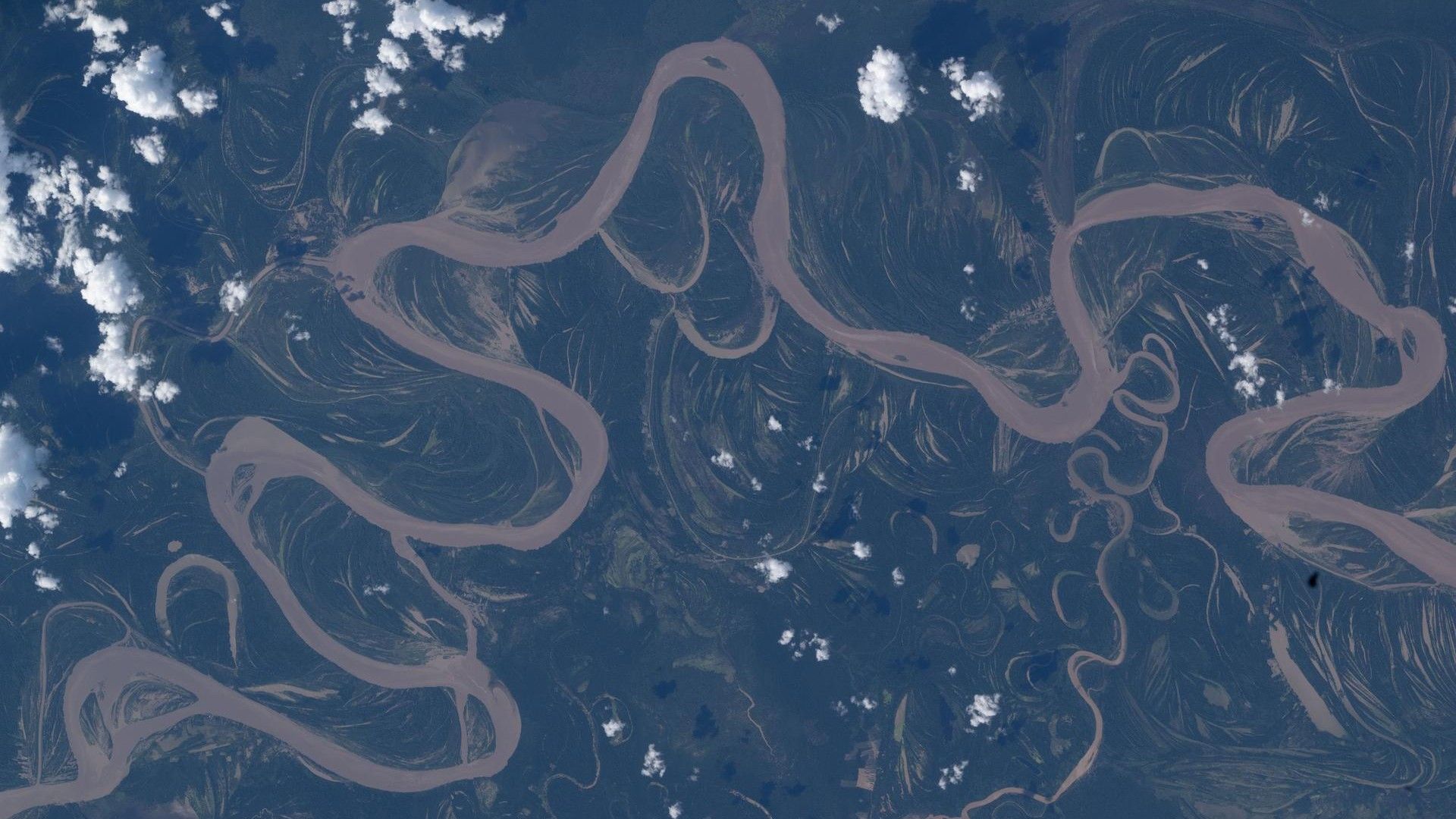
7 Fascinating Facts About the Ucayali River Seen from Space
The Amazon rainforest is home to some of the most dynamic and biodiverse river systems on Earth. On April 30, 2026, NASA astronaut Jessica Meir captured a stunning image of the Ucayali River from the International Space Station, revealing its sinuous path through the dense jungle. This photograph offers a unique perspective on the river’s behavior, its role in the ecosystem, and the challenges it faces. Here are seven things you need to know about this remarkable river as seen from orbit.
1. The Ucayali River Is the Main Headwater of the Amazon
The Ucayali River, originating high in the Peruvian Andes, is one of the two primary sources of the Amazon River. It merges with the Marañón River near Nauta, Peru, to form the Amazon proper. From space, the river appears as a winding ribbon that cuts through the rainforest, illustrating its journey from mountain streams to the vast lowland floodplains. Astronauts often remark on how the river’s bright, muddy color contrasts with the deep green of the canopy, a visual cue of the heavy sediment load it carries from the Andes.

2. Its Meandering Path Is a Classic Example of River Dynamics
The Ucayali is famous for its extreme meanders, which are clearly visible in the space photo. These bends form as the river erodes its outer banks and deposits sediment on the inner curves, a process called lateral migration. Over centuries, the river can shift dramatically, leaving behind oxbow lakes—crescent-shaped bodies of water that mark old channels. From the ISS, astronauts can spot these oxbow lakes as isolated blue patches next to the main river, offering a real-time lesson in fluvial geomorphology. The meandering also creates dynamic habitats for wildlife, including river dolphins and caimans.
3. The River Is a Lifeline for Remote Indigenous Communities
Along its banks, the Ucayali supports numerous indigenous groups, such as the Shipibo-Conibo and Ashaninka. These communities rely on the river for transportation, fishing, and agriculture. The space photograph highlights how settlements often cluster near the water, with small clearings in the forest for crops. Access to clean water is critical, but mining and deforestation upstream threaten both the river’s health and the livelihoods of these peoples. Astronauts’ images help scientists monitor changes in land use and water quality over time.
4. Deforestation Patterns Are Starkly Visible from Orbit
In the image, the pristine rainforest is interrupted by geometric patches of cleared land—farms, ranches, and logging areas. The Ucayali region has experienced some of the highest deforestation rates in the Peruvian Amazon. From space, the “fishbone” pattern of deforestation—where roads extend from the river and smaller plots are cleared perpendicularly—is unmistakable. NASA uses astronaut photography like this to track forest loss and to work with local authorities on conservation efforts. The river itself acts as a natural barrier, with clearing often more intense on one side.
5. The Photo Was Taken During a Period of Riverbank Erosion
The timing of April 30, 2026, coincides with the peak of the wet season in the Amazon. At this time, the Ucayali is swollen with rainwater and Andean snowmelt, causing rapid bank erosion. The sediment-laden water appears tan or brown in the image, while deeper channels are darker. Astronaut Jessica Meir noted that the river seemed to be “clawing at the forest,” a phenomenon that can lead to sudden changes in the river’s course. Such erosion also releases organic carbon from the soil, which contributes to greenhouse gas emissions when broken down.
6. The River Supports Unique Aquatic Ecosystems
The Ucayali is a biodiversity hotspot, home to over 500 species of fish, including the giant arapaima and piranhas. Its floodplains, regularly inundated during the wet season, create temporary lakes that are crucial for fish spawning. These areas are visible from space as lighter green or tan patches near the river. The water’s murky tint indicates high nutrient levels, which support plankton blooms that feed the entire food web. Protecting this river from pollution and overfishing is essential for maintaining the Amazon’s ecological balance.
7. Astronauts Capture These Images to Aid Scientific Research
NASA astronauts take photos of Earth as part of the Crew Earth Observations program. These images are freely available and used by scientists to study everything from river dynamics to urban growth. Jessica Meir’s photo of the Ucayali was specifically requested by researchers interested in how meandering rivers interact with deforestation. The orbital perspective allows them to measure river widths, sediment load, and flood extent in ways that ground surveys cannot. So when you look at this space photo, you’re seeing not just a beautiful scene, but a vital data source for understanding our changing planet.
In summary, the Ucayali River as seen from the International Space Station is far more than a picturesque view. It is a living laboratory of river evolution, a lifeline for indigenous cultures, and a sentinel for environmental change. The photograph taken by astronaut Jessica Meir reminds us of the fragility and importance of the Amazon rainforest—and the power of seeing it from above.